Daytime temperatures returned to the normal mid-60’s this weekend in Los Angeles, but for the past couple of weeks they rose to the paradisiacal 80’s in clear skies and sweet morning air that answered the old question of why anyone would want to live here in a semidesert on the grinding edges of two tectonic plates. It’s a megalopolitan Garden of Eden at times like this, but like Adam and Eve you need to maintain a state of happy obliviousness to enjoy it. That’s the business of chambers of commerce and real estate agencies, which thrive on short memories and buyers who don’t read. When a visitor from the frozen East Coast gazes up along the golden San Gabriel front at all those showplace homes, envious awe slowly gives way to amorphous anxiety, especially after a month of headlines about wildfires and landslides. They’ve got to be kidding themselves up there.
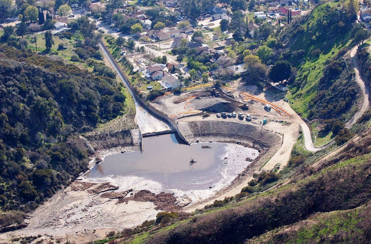
And yes, actually, they are. Several hundred yards above a friend’s house in gentrified Tujunga is a modest dam called the Haines Debris Basin. Its job is not to conserve water, but to absorb the avalanche of mud and boulders that debouches out of the canyon whenever it rains hard, which is not often, but inevitable. (Forty years ago today, Haines Canyon recorded a deluge of 1.4 inches in 30 minutes during a monstrous storm that, among other gruesome catastrophes, washed at least 30 corpses out of Verduga Hills cemetery near Tujunga.) Hundreds of millions of dollars were spent during the 20th century on more than 150 such catchments across Los Angeles County. They may sit empty for decades, but every once in a while they fill up with liquified mountain, which maybe overflows across your neighborhood, fortified by cars and carcasses. In 2010, the Army Corps of Engineers paid a local contractor $3,263,814 just for clearing the muck out of Haines to make room for the next onslaught–a tiny portion of the perpetual taxpayer subsidy behind the LA lifestyle. These basins caught John McPhee’s imagination in a 1988 New Yorker article , which you may safely assume is not widely perused around here today. Where people construct multi-million-dollar homes on the uphill side of an avenue locally admired for its wideness and easy parking, the fact that it was designed as a fire break is not dwelt upon. Likewise for that little lake at the bottom of a scenic canyon. Near Haines is another debris basin that appears on Apple Maps as “Blanchard Canyon Pond,” which must please the real estate agents who list houses inside the precipitous ravine above it as “artistic space” in a “tranquil setting.” Blanchard Canyon was ravaged by a debris inundation on New Year’s Eve, 1933, during a deadly flood memorialized by Woody Guthrie.
In another world, there might be a trusted government that prevents people from hurting themselves in such a hazardous locale, like a lifeguard at the beach. But this is an American paradise, this is freedom, and neither hell nor high water will change it.